The application of GPS in the car
Global Positioning System (GPS) is a satellite-based navigation, positioning and timing system. The receiver calculates the two-dimensional (longitude, latitude) or three-dimensional (longitude, latitude, altitude) position from the data sent by the (GPS) satellite.
The current status of car navigation systems in the United States and Japan GPS
Since it was put into operation, GPS has been gradually opened to civilian use, serving all walks of life. Therefore, major auto companies in the United States and Japan have successively equipped their products with a new generation of information systems and navigation systems. In some cars, the navigation system is no longer an option but standard equipment. Such as Toyota's Windom, Nissan's Cina Honda's Legend Mitsubishi's Galant cars are equipped with electronic navigation systems. The number of new cars sold in Japan in 1997 installed a navigation system in 1/10, which has been increasing year after year. Ford of the United States uses the signals of the global positioning satellite to determine the position of the car to indicate the direction to the driver and provide voice instructions.
Current status of GPS car navigation system in China
The development and application of GPS car navigation system started late in China, but the development momentum is very strong. It is widely used in bank security vehicles and public security patrol cars. Even some large and medium-sized cities have begun to apply some factories and mines to taxis and buses. The department is gradually equipped with GPS receivers.
China combines GPS, geographic information system and modern communication technology to develop a new type of car navigation equipment with functions such as monitoring, dispatching, alarming, monitoring remote flameout and remote fuel cut, automatic archiving of electronic map display, system self-test, etc. It can Display any dynamic position of the car on the electronic map of the instrument at any time and accurately. The electronic map of the navigator automatically tracks the current location of the car and its surroundings. It stores the electronic traffic maps of roads in major cities in China and the high-precision national road network and maps above the village and town level. Query the geographic information of the area with a radius of 300km.
GPS-based car navigation system
The car navigation system can display the current location of the vehicle and intuitively visualize relevant road maps, parking facilities, road attributes (road names, one-way traffic sections, no-turn sections, load restrictions, clearance restrictions, etc.) and other useful service information during operation. Presented in front of the driver, assist the driver to accurately grasp the road to the destination in a strange traffic road environment. When the driver enters the destination into the computer in the car, the computer can be requested according to the city ’s road conditions, traffic lights, The speed limit etc. selects the best driving route and displays it on the screen. It not only instructs vehicles to avoid congested routes, but also helps to evacuate vehicles. In addition, it also has modification functions such as the car owner accidentally missed the intersection, did not take the best route recommended by the system, and the vehicle position deviated from the best route by more than 200m. The system will redesign the best route for the car owner according to the new location. At present, there are many kinds of car navigation system products in various countries around the world, and they are competing to reduce prices, and China is no exception.
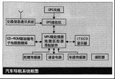
The car navigation system is composed of GPS navigation, autonomous navigation, intelligent map matching device, microprocessor (MPC) or digital information processor (DSP), vehicle speed sensor, gyro sensor, CD-ROM drive or DVD-ROM drive, display and The corresponding software of the electronic map database is composed.
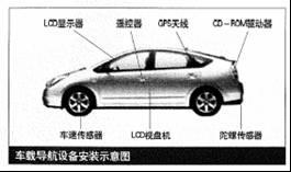
As can be seen from the system block diagram and the installation diagram of the car navigation equipment, the main equipment required on the car are: GPS antenna, GPS receiver (receiving board), computer (CPU), CD-ROM drive and LCD display screen.
CPS navigation equipment
CPS navigation equipment consists of GPS antenna and GPS receiver. There are currently two larger global positioning systems in the sky. In addition to single system reception, combined dual system reception (GPS + GLONASS = GNSS) can also be used. Since the two systems have different operating frequencies, coordinate systems, and transmission identification methods, the antenna and receiver parameters must be changed accordingly before they can work. According to the difference of satellite inclination, orbital surface and the number of satellites distributed on it (for example, 55 ° inclination of GPS system, 6 orbital surfaces, 4 satellites are distributed on each orbital surface, the operating period is 11 hours and 58 minutes) Up to 8 satellite parameters may be received. According to the positioning requirements, as long as 4 satellite parameters are received, the ground positioning coordinates can be obtained. In order to reduce the occlusion effect of high-rise buildings in the city. The 12-channel GPS-OEM board produced by American Rockwell Company is often used as the host of GPS receiver.
Autonomous navigation equipment
The device consists of vehicle speed sensor and gyro sensor. When the car is driving in tunnels, high-rise buildings, viaducts, high mountain streams, dense forests, etc., it will lose contact with GPS. At the moment when the signal is interrupted, the auto-guided autonomous navigation system in the machine will move forward from the car. Speed ​​detects the speed pulse, through the data processing of the automobile microprocessor (MPU), the distance traveled is directly obtained from the speed and time. In order to reduce the error in the calculation accuracy due to the thermal expansion of the tire during high-speed driving, a distance coefficient should be corrected to improve the accuracy of navigation. The gyro sensor can directly measure the change of the direction of travel and the status of the driving route. The distance traveled by these curves and the satellite navigation latitude and longitude will produce a larger error. At this time, the correct position of the car can only be obtained by the operation correction of the gyro sensor and the microprocessor. Digital odometers are often used for vehicle speed sensors, and piezoelectric crystal gyros are used for gyro sensors.
Map matcher
There are certain errors on the electronic map of the car coordinate position data, the direction of travel and the driving route track measured by GPS navigation and autonomous navigation (including vehicle speed sensor and gyro sensor). In order to correct these errors, map matching technology is needed. Add a map matching circuit to perform timing digital correlation matching on the route of the car (including the trajectories detected by various sensors) and the deviation of the road on the electronic map, make automatic corrections, and then the microprocessor arranges the program for rapid processing in real time. Get the correct position of the car on the electronic map.
With the advancement of technology in recent years, the use of fuzzy logic control principles to replace the original map matching device composed of complex digital correlation matching technology can greatly simplify the system structure, reduce costs and improve accuracy.
LCD monitor
The development of flat panel displays in the world shows that thin film transistor active matrix liquid crystal display (TFTAMLCD) is a development direction. Because it is equipped with a semiconductor switching device behind each pixel to drive, it realizes high-brightness video image display, which has the advantages of good contrast, many scanning lines, wide viewing angle, low reflection and so on. The Japan Navigation Research Association has established three primary color (RGB) TFTLCD as a standard for navigation, with a size of 5.6 inches, 224,640 pixels (234x960), and 6.4 inches, 449,280 pixels (234x1920). Due to its wide viewing angle and high brightness, this type of display allows clear pictures to be seen on both the front passenger seat and the rear seat, and is therefore widely used. It has been produced in China.
Recently, a wide-screen 7-inch LCD monitor with 336,960 pixels (234x1440) has been launched internationally, with a diagonal of 180mm and a longitudinal mode ratio of 16: 9. It has general household color TV functions. It can provide dual and picture-in-picture pictures by adding circuits. The functions such as distance expansion screen display and so on have realized various functions such as navigation map screen, TV reception, and readjustment of multi-frequency information reception, which bring pleasure to the driver for long-distance driving.
Communication system
The mobility of the vehicle determines that the communication of the system must use the radio communication method. The commonly used communication methods are conventional communication and cluster communication GSM short message services. Among them, the GSM short message service is currently popular for positioning data transmission. Because of its wide coverage, global communication can be achieved, but the time problem is an important factor restricting its development. China's GSM public digital mobile communication is the digital mobile communication system with the largest coverage, the highest system reliability, and the most possession. The use of GSM transmission, GPS information, and other information is an economical and effective communication method.
Online Bus Tracking and Control System Based on GPS
Since the bus line is fixed, there is no requirement to select the best driving route. The purpose of the GPS positioning system is mainly to track and control the timely dispatch of vehicles, which is convenient for passengers. To further facilitate passengers and dispatch the fleet, Singapore New World Bus (SBS) has been experimenting with the GPs bus on-line tracking control system. The system includes: passenger display cards installed at major bus stops. GPS-based bus online positioning system (each bus is equipped with on-board computer and GPS positioning machine) bus driver display screen, central control computer, etc. The central control computer keeps track of and monitors each bus to monitor its scheduled arrival time and even the attendance rate of each bus and at each station, passengers on the station display signs to notify passengers trying to wait for the bus about the operation of the bus, so that passengers can Plan your trip well and reduce waiting times, while also allowing the fleet to better adjust the frequency of vehicle departures.
GPS-based taxi fleet automatic transfer system
Taxis have become an important mode of transportation after buses in major cities. Due to the low cost of taxis in Singapore, it is difficult to rent a car during peak hours and the average empty rate of taxis is very high. In order to improve the efficiency of road utilization and more effective use of taxis, several large taxi companies in Singapore have adopted and are planning to adopt a GPS-based taxi fleet automatic dispatch system. This system allows passengers waiting for cars to access the computer to control the computer by telephone After inputting the starting point and time, the computer searches for an empty car close to the passenger through GPS and displays the required information on the driver's display screen in a flashing manner. If the driver accepts the guest, press the answer key to confirm the acceptance. After the driver presses the confirmation key, the guest's starting point and other information will be displayed (to prevent the driver from rejecting the load). If the driver does not accept it, the system will automatically search for another nearer taxi after pressing the "don't accept button". For regular users, the system can also provide services such as scheduled taxi scheduled pick-ups.
The benefits of the GPS-based fleet dispatching system are not only the effective dispatch of taxis, but more importantly, the taxis equipped with this system have become vehicle probes, thousands of 24-hour service probes It provides extremely valuable basic data for urban traffic monitoring and control. GPS-based driving recorder
The driving recorder is mainly used to record the vehicle's running route, running speed and acceleration changes so that the management department can check the running status of the vehicle. It plays an important role in restricting the driver's bad driving behaviors such as driving in fatigue, vehicle speeding and other traffic violations, and ensuring the safety of the vehicle. And provides effective law enforcement tools for traffic safety management departments. In the 1970s, countries such as the European Union and Japan began to forcefully install car driving recorders on some passenger and freight cars in a three-dimensional form. The driving recorder is composed of a GPS receiver, an electronic map and an electronic map matcher, a processor, etc. It receives GPS positioning data of a moving vehicle in real time and converts it through coordinates, from geographic coordinates to screen coordinates with certain symbols on the electronic map The dynamic trajectory showing the vehicle positioning can be displayed in full screen, zoomed and hierarchical. It can also select any road segment to play back the vehicle trajectory and choose the playback speed at will.
Since the task of the driving recorder is only to describe the trajectory of the vehicle, no communication system is needed, so the structure is very simple, the cost is low, and it is easy to implement. Therefore, it is widely used at home and abroad.
MOSO Fixed Output LED Driver is a type of compact size, IP67, high quality
LED driver with cost efficiency working in constant current mode. This control
gear is designed for industrial LED light fixtures, like linear or round high
bay, low bay lights, or flood lights, canopy lights in industrial area, or
factories, warehouses.


This Fixed Output LED Driver got global safety certifications, including UL, CE, TUV, CB, ENEC, SAA, BIS, etc. The LED control gear has universal input voltage, from 90~305Vac. It is a reliable product compatible with various application and different countries.
Due to the high IP rating, the LED power supply can be used for dry, damp, wet locations. It is suitable for built-in a luminaire body, or it can be installed outside of the fixture. The perfect cooling design can ensure the product reliability and long lifetime for at least 50,000hours operation at least) minimum. Drivers with dimming 0~10V & PWM is available.
MOSO grants the product with 5 years global warranty. Customer can refer to Warranty Policy, find the closest MOSO distributors or sales representatives, to get a local replacement in case of any failure.
Fixed Output LED Driver
Fixed Output LED Driver,Current Fixed Fixed Output LED Driver,Independent Fixed Output LED Driver,Output LED Driver
Moso Electronics , https://www.mosoleddriver.com